Vocabulary for 3rd, 4th 5th & 6th grade
know the meanings of and/or be able to identify these terms:
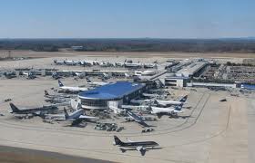
airport- A leveled piece of land where aircraft can take off and land, usually with hard-surfaced landing strips, a control tower, hangars, aircraft maintenance and refueling facilities, and accommodations for passengers and cargo.

altitude- The height of a thing above a reference level, especially above sea level or above the earth's surface

atlas- A book or bound collection of maps, sometimes with supplementary illustrations and graphic analyses

- bank- 1. A piled-up mass, as of snow or clouds. 2. A steep natural incline
- 3. An artificial embankment. 4. The slope of land adjoining a body of water, especially adjoining a river, lake, or channel.

basin- 3. A region drained by a single river system: a depression in the earth's surface

bay- A body of water partially enclosed by land but with a wide mouth, giving access to the sea

- beach- 1. The shore of a body of water, especially when sandy or pebbly
- The zone above the water line at a shore of a body of water, marked by an accumulation of sand, stone, or gravel that has been deposited by the tide or waves.

biome- A major regional or global biotic community, such as a grassland or desert, characterized chiefly by the dominant forms of plant life and the prevailing climate.

butte- A hill that rises abruptly from the surrounding area and has sloping sides and a flat top.

canal- An artificial (man made) waterway or artificially improved river used for travel, shipping, or irrigation.

canyon- A narrow chasm with steep cliff walls, cut into the earth by running water; a gorge

cape- A point or head of land projecting into a body of water.

cave- A hollow or natural passage under or into the earth, especially one with an opening to the surface.

channel- 1. The bed of a stream or river.2. The deeper part of a river or harbor, especially a deep navigable passage 3. A broad strait, especially one that connects two seas.

cliff- A high, steep, or overhanging face of rock.

climate- 1. The meteorological (weather ) conditions, including temperature, precipitation, and wind, that characteristically prevail in a particular region 2. A region of the earth having particular meteorological (weather ) conditions

coast- Land next to the sea; the seashore.

community- 1. A group of people living in the same locality (place) and under the same government.

compass- A device used to determine geographic direction, usually consisting of a magnetic needle or needles horizontally mounted or suspended and free to pivot until aligned with the earth's magnetic field.

compass rose- a circle or decorative device printed on a map or chart showing the points of the compass N, S, E, W.

continent- One of the principal land masses of the earth, usually regarded as including Africa, Antarctica, Asia, Australia, Europe, North America, and South America.

country- A nation or state; The territory of a nation or state

creek- A small stream, often a shallow or intermittent tributary to a river.

current- A flowing; flow, as of a river; something that flows, as a stream; the most rapidly moving part of a stream.

dam- A barrier constructed across a waterway to control the flow or raise the level of water
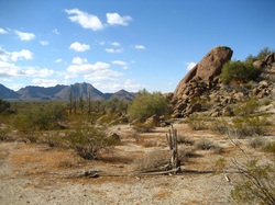
desert- A barren or desolate area, a dry, often sandy region of little rainfall, extreme temperatures, and sparse vegetation, A region of permanent cold that is largely or entirely devoid of life
divide- A dividing point or line: A ridge of land; a watershed
downstream- In the direction of a stream's current.
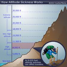
elevation- 1. The height to which something is elevated above a point of reference such as the ground. 2. The height of a thing above a reference level; altitude.
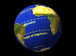
equator- The imaginary great circle around the earth's surface, equidistant from the poles and perpendicular to the earth's axis of rotation. It divides the earth into the Northern Hemisphere and the Southern Hemisphere
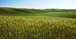
field- A broad, level, open expanse of land.
foothill- A hill near the base of a mountain or mountain range.
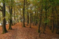
forest- A dense growth of trees, plants, and underbrush covering a large area
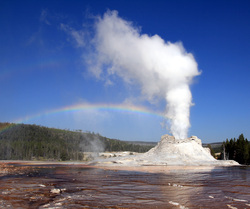
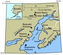
geyser- A natural hot spring that intermittently ejects a column of water and steam into the air.

glacier- A huge mass of ice slowly flowing over a land mass, formed from compacted snow.

globe- A body with the shape of a sphere, especially a representation of the earth in the form of a hollow ball.

gulf- A large area of a sea or ocean partially enclosed by land,

harbor- A sheltered part of a body of water deep enough to provide anchorage for ships.
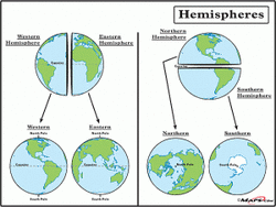
hemisphere- A half of a sphere bounded by a great circle.

highway- A main public road, especially one connecting towns and cities.

hill- A well-defined natural elevation smaller than a mountain

horizon- The apparent intersection of the earth and sky as seen by an observer

iceberg- A massive floating body of ice broken away from a glacier.
indigenous- Originating and living or occurring naturally in an area or environment.
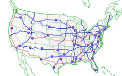
interstate- Involving, existing between, or connecting two or more states.

irrigated land- To supply (dry land) with water by means of ditches, pipes, or streams;

island- A land mass, especially one smaller than a continent, entirely surrounded by water.
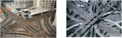
junction- A place where two things join or meet, especially a place where two roads or railway routes come together and one terminates.

key, map- A table, glossary, or cipher for decoding or interpreting.

lake- A large inland body of fresh water or salt water

latitude- The angular distance north or south of the earth's equator, measured in degrees along a meridian, on a map or globe.

legend, map- An explanatory table or list of the symbols appearing on a map or chart.

locks- A section of a waterway, such as a canal, closed off with gates, in which vessels in transit are raised or lowered by raising or lowering the water level of that section.

longitude- Angular distance on the earth's surface, measured east or west from the prime meridian.

map- A representation, usually on a plane (flat) surface, of a region of the earth

marsh- An area of soft, wet, low-lying land, with grassy vegetation and forming a transition zone between water and land.

meadow- A piece of grassland, either in its natural state or used as pasture or for growing hay.

mesa- A broad, flat-topped elevation with one or more clifflike sides,

mine- An excavation (hole) in the earth from which ore or minerals can be extracted.

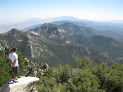
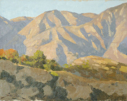
mountain- A natural elevation of the earth's surface having considerable mass, generally steep sides, and a height greater than that of a hill.

mouth, river- A natural opening, as the part of a stream or river that empties into a larger body of water or the entrance to a harbor, canyon, valley, or cave.

natural- Present in or produced by nature

North Pole- The northern end of the earth's axis of rotation, a point in the Arctic Ocean.

oasis- A fertile or green spot in a desert or wasteland, made so by the presence of water

ocean- The entire body of salt water that covers more than 70 percent of the earth's surface.

pass- A way, such as a narrow gap between mountains, that affords passage around, over, or through a barrier.

peak- 1. The pointed summit of a mountain 2. The mountain itself.

peninsula- A piece of land that projects into a body of water and is connected with the mainland by an isthmus

physical map- of, relating to, or resembling material things or nature

plain- An extensive, level, usually treeless area of land.

plateau- An elevated, comparatively level expanse of land; a tableland

point- A tapering extension of land projecting into water

political map- Shows the boundaries of cities, states, and countries.

pond- A still body of water smaller than a lake.
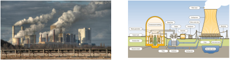
power plant- A complex of structures, machinery, and associated equipment for generating electricity

prairie- a large level piece of grassland; meadow.

railroad- A road composed of parallel steel rails supported by ties and providing a track for locomotive-drawn trains or other wheeled vehicles.

range- An extensive area of open land on which livestock wander and graze.

rapids- part of a river where the current is very fast and turbulent

reef- A strip or ridge of rocks, sand, or coral that rises to or near the surface of a body of water.

reservoir- A natural or artificial pond or lake used for the storage and regulation of water

resources- Something that can be used for support or help.

ridge- 1. A long, narrow upper section or crest: the ridge of a wave 2. A long, narrow chain of hills or mountains. Also called ridgeline.3. A long, narrow elevation on the ocean floor.

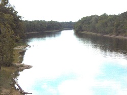
river- A large natural stream of water emptying into an ocean, lake, or other body of water and usually fed along its course by converging tributaries.

road- 1. An open, generally public way for the passage of vehicles, people, and animals. 2. A course or path

road map- A map, especially one for motorists, showing and designating the roads of a region; showing roads, distances, etc. in a country or area

rural- 1. Relating to, or characteristic of the country 2. Relating to people who live in the country: rural households 3. Of or relating to farming; agricultural.

sandbar- A ridge of sand formed in a river or along a shore by the action of waves or currents.

sand dune- a ridge of sand created by the wind; found in deserts or near lakes and oceans

scale- A proportion used in determining the dimensional relationship of a representation to that which it represents
sea- 1. A tract of water within an ocean 2. A relatively large body of salt water completely or partially enclosed by land 3. A relatively large landlocked body of fresh water
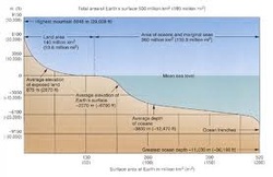
sea level- The horizontal plane (line) corresponding to the surface of the sea between high and low tide.

seaport- A harbor or town having facilities for seagoing ships.

shoreline- The edge of a body of water
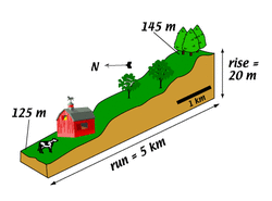
slope- A stretch of ground forming a natural or artificial incline

snowline- The lower boundary of a snow-covered area, especially one that is perennially covered, such as the snowcap of a mountain.

source- The point of origin (beginning), such as a spring, of a stream or river

South Pole- The southern end of the earth's axis of rotation, a point in Antarctica

strait- A narrow channel joining two larger bodies of water.

swamp- 1. A seasonally flooded bottomland with more woody plants than a marsh and better drainage than a bog 2. A lowland region saturated with water.

timber- Trees or wooded land considered as a source of wood.

timberline- 1. The elevation in a mountainous region above which trees do not grow. 2.The northern or southern latitude beyond which trees do not grow

town- A population center that is larger than a village and smaller than a city.

tropic- either of the parallel lines of latitude at about 23½°N (tropic of Cancer) and 23½°S (tropic of Capricorn) of the equator; the tropics that part of the earth's surface between the tropics of Cancer and Capricorn; the Torrid Zone

tunnel- An underground or underwater passage

urban- Relating to, or located in a city.

upstream- In a direction opposite to that of a stream's current

valley- 1. An elongated lowland between ranges of mountains, hills, or other uplands, often having a river or stream running along the bottom 2. An extensive area of land drained or irrigated by a river system.

village- A small group of dwellings in a rural area smaller in population than a town

wetland- A lowland area, such as a marsh or swamp, that is saturated with moisture, especially when regarded as the natural habitat of wildlife:
Additional Vocabulary for 5th & 6th grades

archipelago- 1: an expanse of water with many scattered islands, 2: a group of islands

arctic region- A region between the North Pole and the northern timberlines of North America and Eurasia
arm- an inlet of water (as from the sea)

atoll- a coral island consisting of a reef surrounding a lagoon

axis- 1: a straight line about which a body or a geometric figure rotates, 2: a plant stem

bayou- an area of water in which the water moves very slowly and is filled with many plants

breakwater- a wall that is built out into the sea to protect a harbor or beach from the force of waves
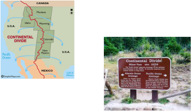
continental divide- the line of highest points of land separating the waters flowing W from those flowing E, or N from S, coinciding with various ranges.

cove- a small sheltered inlet or bay

delta- a piece of land shaped like a triangle that is formed when a river splits into smaller rivers before it flows into an ocean

dike- a bank or mound of earth that is built to control water and especially to protect an area from flooding

drainage basin- An area drained by a river system.

estuary- 1. The part of the river where its current is met by the tides of the ocean

ford- A shallow place in a body of water, such as a river, where one can cross

fjord- A long, narrow, deep inlet of the sea between steep slopes.

gorge- A deep narrow passage with steep rocky sides; a ravine

grid- A pattern of regularly spaced horizontal and vertical lines forming squares on a map, a chart

headland- A point of land, usually high and with a sheer drop, extending out into a body of water; a promontory

inlet- a. A bay or cove, along a coast, b. A stream or bay leading inland, c. A narrow passage of water, as between two islands.

International Date Line- An imaginary line through the Pacific Ocean roughly corresponding to 180° longitude, to the east of which, the calendar date is one day earlier than to the west.

isthmus- A narrow strip of land connecting two larger masses of land.

lagoon- A shallow body of water, especially one separated from a sea by sandbars or coral reefs.

levee- An embankment raised to prevent a river from overflowing.

Pangaea- A hypothetical super-continent that included all the landmasses of the earth

parallel- Any of the imaginary lines representing degrees of latitude that encircle the earth parallel to the equator

piedmont- An area of land formed or lying at the foot of a mountain or mountain range.

plate tectonics- a geologic theory that describes the earth's crust as divided into a number of plates.

precipice- An overhanging or extremely steep mass of rock, such as a crag or the face of a cliff.

projection- A systematic transformation of the latitudes and longitudes of locations on the surface of a sphere into locations on a plane. creating a sphere on a flat surface.

savanna- A flat grassland of tropical or subtropical regions

shoal- 1. A shallow place in a body of water.2. A sandy elevation of the bottom of a body of water, constituting a hazard to navigation; a sandbank or sandbar.

sound- a. A long, relatively wide body of water, larger than a strait or a channel, connecting larger bodies of water. b. A long, wide ocean inlet. sphere

spit- A narrow point of land extending into a body of water.

steppe- A vast semiarid grass-covered plain.

topographical map- Graphic representation of the surface features of a place or region on a map, indicating their relative positions and elevations.

topography- The surface features of a place or region.

tributary- A stream that flows into a larger stream or other body of water.

tundra- A treeless area between the icecap and the tree line of Arctic regions, having a permanently frozen subsoil

watershed- The region draining into a river, river system, or other body of water.
